
Links
- Mail Me
- Westward Expansion Pre-1820 Email List
- The First American West:The Ohio River Valley, 1750-1820
- Early American Roads and Trails
- Western Movement
- The Colonial Heritage of St. Louis Missouri
Blogroll Me!
Blogroll
Archives
- 11/07/2004 - 11/14/2004
- 11/14/2004 - 11/21/2004
- 11/21/2004 - 11/28/2004
- 11/28/2004 - 12/05/2004
- 12/05/2004 - 12/12/2004
- 12/12/2004 - 12/19/2004
- 12/19/2004 - 12/26/2004
- 01/02/2005 - 01/09/2005
- 01/23/2005 - 01/30/2005
- 01/30/2005 - 02/06/2005
- 02/06/2005 - 02/13/2005
- 12/11/2005 - 12/18/2005
Writings, discussions and studies about the US westward migration between the Revolutionary War and the beginning of the Oregon Trail
Monday, November 08, 2004
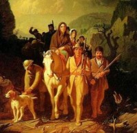
Heading west from Eastern Pennsylvania
to pick up the Ohio at or near Pittsburg, and then to take the river to Kentucky or other parts.
This road was called, among other names, the Forbes Road. On a page called Migration Trails in Early Pennsylvania, we get this description:
FORBES ROAD - Raystown Path and The Old Trading Path
In 1758, General John Forbes convinced the Army to use the Raystown Path (Bedford) as a military road. The road to the east had been cleared by Colonel James Burd. However the road was nearly impassable so Colonel Bouquet worked ahead of the advancing army to make the improvements and widen the old bridle path or cut new paths over the hills. By November 24 the army had reached Fort Duquesne. In 1785 the State of Pennsylvania authorized 'The Pennsylvania Road' from Harrisburg to Pittsburgh following the old Forbes Road. The road was changed in many ways. It now ran through Greensburg rather than Hannastown and took a south branch through Wilkinsburg. The Great Conestoga Road, completed in 1741, and the later Lancaster Pike (opened in 1794) went from Philadelphia to Lancaster. These two roads were linked and this was now the main migration route from the east to the Ohio Valley after the Revolution until the building of the Erie Canal in 1834. This road combined the Raystown Path from near Pittsburgh to Harrisburg and the Allegheny Path to Philadelphia.
This site is worth looking at. It has a nice map of several of the early trails. It's especially interested in the migration from eastern PA to Westmoreland County, but includes routes with a short description for all over the state.
![]()